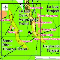
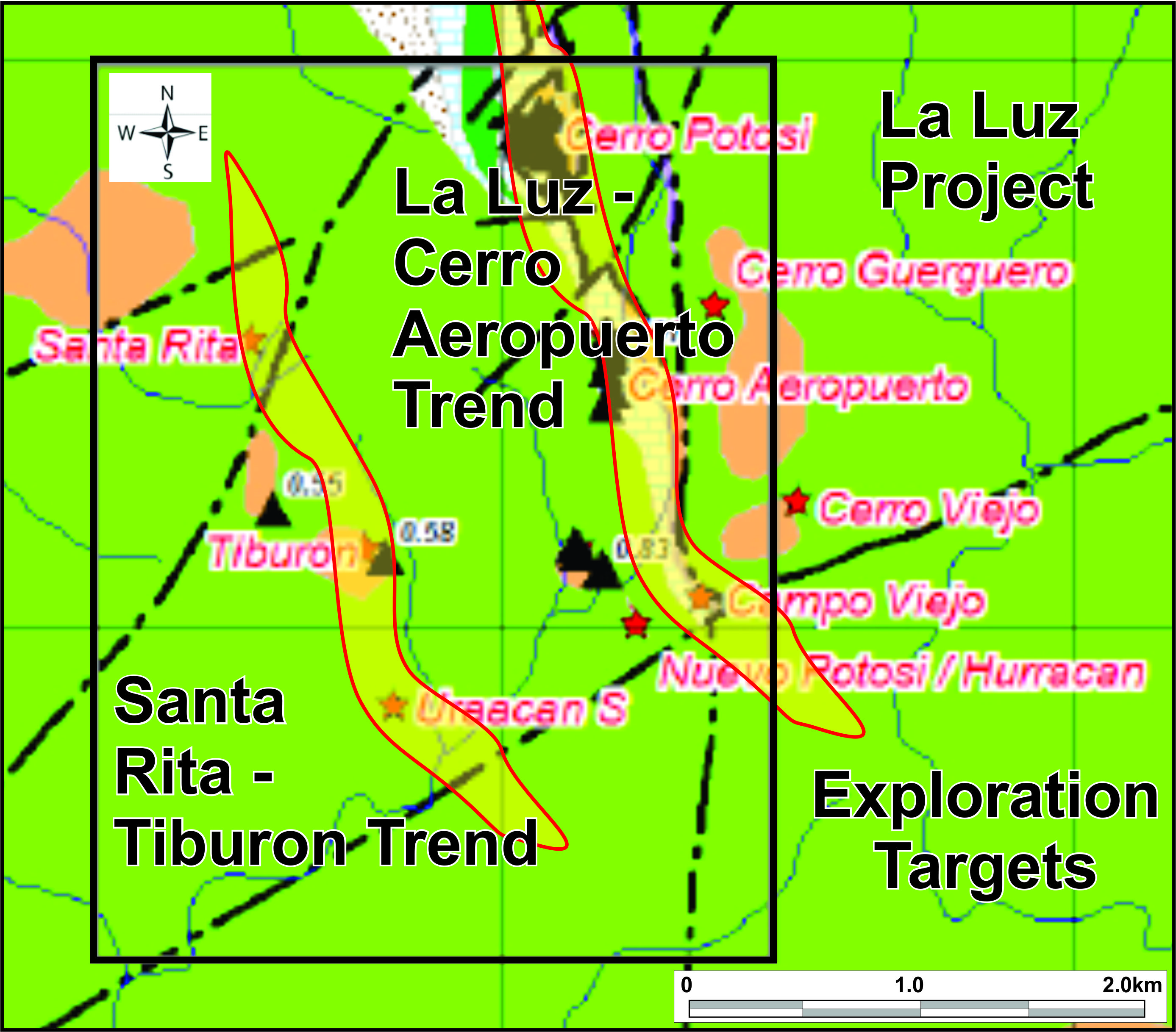
Regional Exploration, Nicaragua La Luz Gold Project
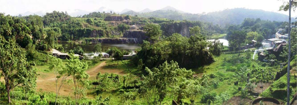
The 1200 hectare La Luz Gold-Silver Project is located in the south-west portion of the Borosi Concessions and contains the past producing La Luz Mine that produced 17.1 million tonnes of ore grading 4.14 g/t gold (2.3 million ozs gold) between 1912 and 1968. One kilometre south of the La Luz Mine, Calibre has defined an NI 43-101 Inferred Mineral Resource, at the Cerro Aeropuerto gold-silver deposit containing 707,750 ozs gold and 3.14 million ozs silver.
Immediately adjacent to the La Luz Mine is the Cerro Potosi Target which hosts near-surface, gold-bearing garnet-epidote skarn mineralization parallel to and in the footwall of the historic mine. In 2008, Yamana Gold Inc. completed a drill program that highlighted several near surface intercepts including; 16.2 metre grading 4.18 g/t gold (39.3m – 55.5m), 32.0 metre grading 2.50 g/t gold (56.0m – 88.0m), and 15.0 metre grading 1.78 g/t gold (39.0m – 54.0m)*. Calibre completed sampling in 2015 at Cerro Potosi and continuous chip sampling of outcrop returned 10.2 metres grading 2.05 g/t Au and 178.1 g/t Ag. Additionally selected grab samples of mineralized skarn material included up to 18.9 g/t Au and 96.0 g/t Ag.
History of Gold Mining at Siuna
Gold mineralization was first discovered in the Siuna area in the late 1800’s by indigenous people that reported “favourable results” from gold panning. The first organized, small-scale mining was carried out by the La Luz and Los Angeles Mining Company from 1908 – 1928, during which time an estimated 523,000 short tons grading 0.25 oz/ton gold was produced. The property was purchased in 1936 by La Luz Mines Ltd. who operated the gold mine continuously by underground and open pit methods until 1968. Production was only halted when a hurricane permanently damaged the mine’s hydroelectric plant. During this period, an estimated 17 million short tons grading 0.12 oz/ton gold was produced. In recent times, only small scale mining by open pit methods was carried out by CODEMINA from 1979 – 1983, during which approximately 840,000 short tons grading 0.054 oz/ton gold was produced. Due to the unplanned shut-down of mining operations at the La Luz mine in 1968, it is believed that significant underground and open pit gold resources remain. Rosario estimated in 1974 that the La Luz Mine contained and estimated that the underground portion of the deposit contains 8.2 million tons grading 0.078 oz/ton gold, for approximately 640,000 ounces of gold. Rosario’s historic estimate incorporated a 0.05 oz/ton cut-off and 10% dilution. *
In 1997, Greenstone Resources Ltd. estimated near surface mineralization at the La Luz Mine of 720,000 tons grading 0.049 oz/ton gold, totaling approximately 35,000 ounces of gold. The resource estimates produced by Rosario and Greenstone pre-date NI 43-101 standards but are believed to be relevant as they are based on surface and underground drilling and drift sampling. However, the historic resource estimate should not be relied upon until verified. Both historic resources are open at depth and along strike.
*The Company cautions that it has not verified the quality and accuracy of the historic sampling and drilling results, and while the historic figures were generated from sources believed to be reliable and are relevant, readers are cautioned not to rely upon them.
La Luz Mine
Mineralization at the La Luz mine is hosted by a sediment-dominant sequence of the Todos Santos Formation, comprising interbedded massive limestone, thin bedded impure limestone, limy mudstone, greywacke, breccia, arkose, quartzite and conglomerate together with lesser tuffs and andesite volcanics, which are referred to as the Mine Series. These units have been altered to a prograde garnet-silica skarn assemblage, locally overprinted by a retrograde epidote±chlorite skarn. Within areas of epidote-rich skarn, smaller zones with disseminated pyrite, chalcopyrite, sphalerite and hematite host the gold-bearing zones previously mined at La Luz (Plecash, 1963).
The most important of the interbedded volcanic units at La Luz is the Hanging Wall Andesite, a massive to porphyritic andesite with local pyroclastic and tuffaceous textures, which is conformable with the Mine Series sediments and cores a tight syncline. It has been traced in mine workings for over 1100 metres strike length and 230 metres width (Arengi, 2003).
The principal zone (No. 1) mined at La Luz lies in the immediate footwall of the Hanging Wall Andesite on the east limb of the syncline, which dips to the southwest at about 65°. Plecash et al (1963) suggest that the Hanging Wall Andesite acted as an impermeable boundary which focused the mineralizing fluids within the subjacent Mine Series calcareous sediments. Other impermeable dikes and sills, in particular the K Dike serpentinite, also controlled fluid flow and the distribution of gold-bearing mineralization.
The La Luz Mine was developed initially from an open pit and then underground from seven levels to a depth of 440 metres, with reported production of 2.3 million ounces of gold. With depth, as the andesite/skarn contact flattens out towards the trough of the syncline, gold grades drop off and the base of the No. 1 zone rakes toward the northwest, parallel to the fold axis. The highest gold grades in the No. 1 zone were immediately adjacent to the Hanging Wall Andesite contact; they generally decreased with distance from it and the footwall of the No. 1zone was an assay cut-off (Plecash, 1963). The geometry of the No. 2 zone is more complicated; it lies in the footwall of the No. 1 zone is controlled by lithologies of the calcareous sediments and by orientations of the K dike and other impermeable bodies. The two zones were connected by an envelope of lower-grade skarn mineralization.
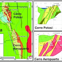
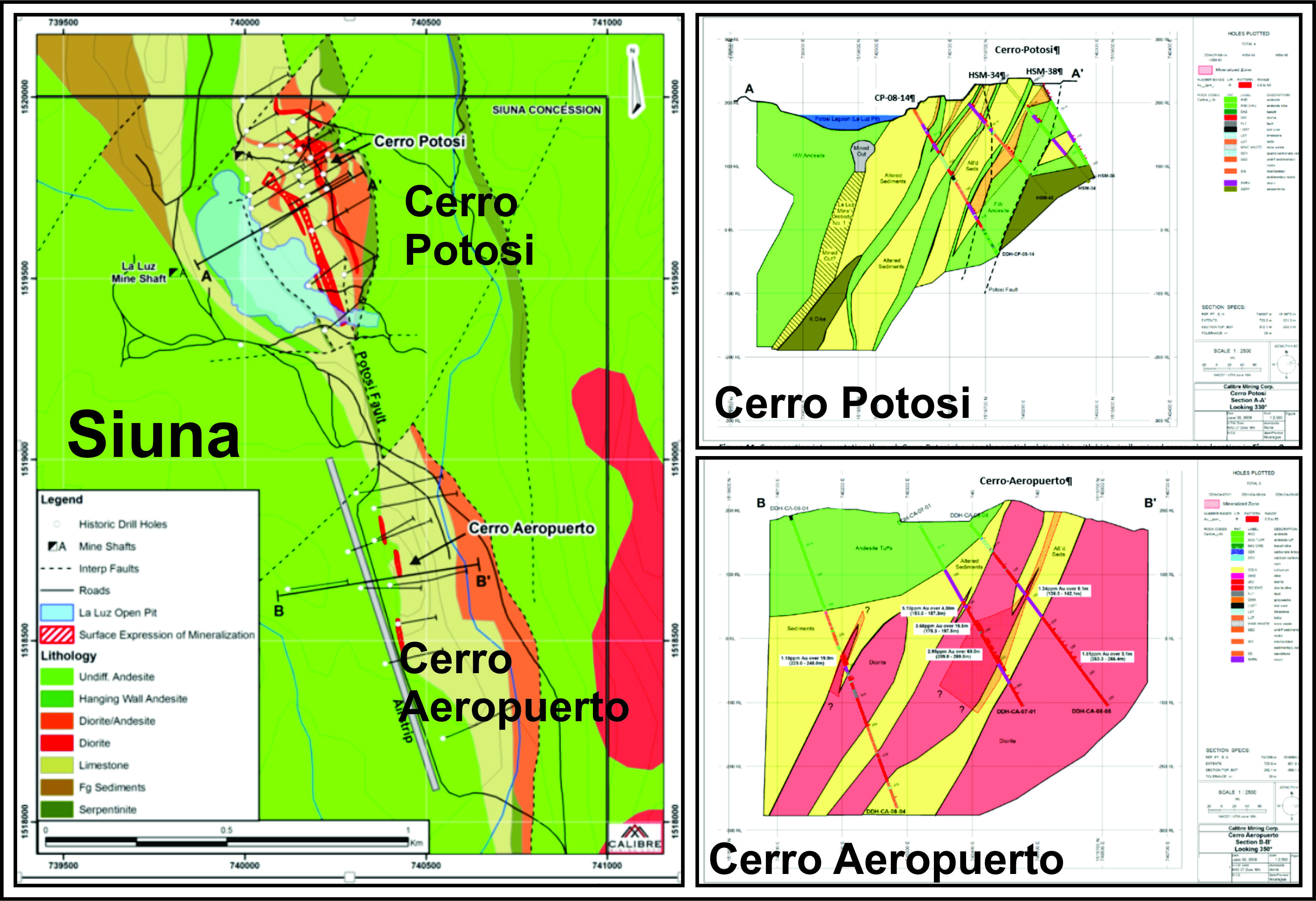
Cerro Potosi
Cerro Potosí is the small hill that lies immediately northeast of the water-filled La Luz Mine open pit. It covers the Mine Series sedimentary/volcanic package in the footwall of the previously exploited No. 1 zone. The style of mineralization is identical to that of the La Luz Mine, with prograde garnet-skarn-diopside skarn developed extensively within the Mine Series calcareous sediments and more localized epidote-rich retrograde skarn locally accompanied by sulphides. Several mineralized northwest-trending gold-bearing zones have been recognized proximal to hornblende-feldspar porphyry dikes at Cerro Potosí. The sediments consist of a package of well-laminated mudstone, calcareous mudstone, marble and lesser arenite which show varying degrees of folding and disruption. Depending on the attitude of the sediments, the dikes vary from slightly to highly discordant. The northwest trending andesite dikes are transected by north to northeast trending faults with left lateral displacement.
Cerro Aeropuerto
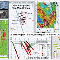
The Cerro Aeropuerto prospect is located one kilometre south of Cerro Potosi . The system contains gold and base metal bearing quartz veins and replacement style mineralization. Drilling by Yamana Gold Inc. suggests that the system follows a north-trending, steeply west-dipping zone that can be traced for over 500 metres along strike and over 300 metres down-dip. Drilling highlights from 2007/2008 included an intercept of 24 metres grading 5.75 g/t gold. In 2011, Calibre used the existing drilling data to prepare an NI 43-101 compliant inferred resource estimate of 707,750 ounces of gold and 3,144,500 ounces of silver at Cerro Aeropuerto (details below).
La Luz Gold-Silver Project - Cerro Aeropuerto Deposit NI 43-101Inferred Resource;
| TONNES | GRADE (AU G/T) |
GRADE (AG G/T) |
GRADE (AUEQ G/T) |
CONTAINED AU (OUNCES) | CONTAINED AG (OUNCES) | CONTAINED AUEQ (OUNCES) |
|---|---|---|---|---|---|---|
| 6,052,000 | 3.64 | 16.16 | 3.89 | 707,750 | 3,144,500 | 757,000 |
- Resource models used Inverse Distance grade estimation within a three-dimensional block model with mineralized zones defined by wireframed solids and a base cutoff grade of 0.6 g/t.
- Resource Estimate for Cerro Aeropuerto detailed in Technical Report titled NI 43-101 Technical Report and Resource Estimation of the Cerro Aeropuerto and La Luna Deposits, Borosi Concessions, Nicaragua by Todd McCracken, dated April 11, 2011.
- Numbers may not add exactly due to rounding.
- Gold Equivalent (AuEq) for Cerro Aeropuerto was calculated using $1058/oz Au for gold and $16.75/oz Ag for silver, and metallurgical recoveries and net smelter returns are assumed to be 100%.
- Mineral Resources that are not mineral reserves do not have economic viability
- The quantity and grade of reported inferred resources in this estimation are uncertain in nature and there has been insufficient exploration to define these inferred resources as an indicated or measured mineral resource and it is uncertain if further exploration will result in upgrading them to an indicated or measured mineral resource category.