Exploración Regional Northen Siuna District
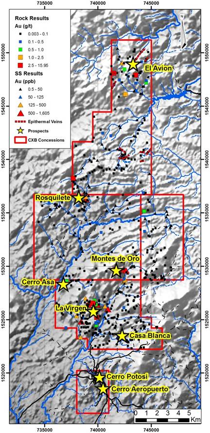
The Northern Siuna District; is located three kilometres north of the La Luz Gold Project. This 214 km2 area hosts the Montes de Oro Gold Project where the 2015 Phase I drilling program intercepted 37.7 metres grading 1.19 g/t Au, 12.97 metres grading 2.60 g/t Au, and 18.8 metres grading 0.97 g/t Au. Additionally Calibre continues to advance a number of La Luz “look-alike” targets within the district. Additional targets include Mina Victoria Project which includes anomalous rock and soils sampling which has defined an anomaly 3.5 km by 2.0 km. Additional zones include Cerro Aza, where a gold in soil anomaly was extended in 2015, Roskilete, and San Miguel.
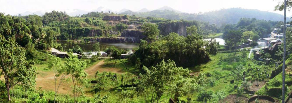
Calibre’s 100% owned Siuna District is located approximately 230 kilometres northeast of Managua, Nicaragua. The concession includes the past producing La Luz Mine that produced 17.1 million tonnes of ore grading 4.14 g/t Au (2.3 million oz. gold) from a garnet-epidote skarn system (Arengi, 2002). The town of Siuna is located within the concession.
There are two main prospects on the Siuna Project. The Cerro Potosi prospect in the north hosts near-surface, gold-bearing garnet-epidote skarn mineralization parallel to and in the footwall of the historically exploited ore body of the La Luz Mine. In 2008, Yamana Gold Inc. completed a drill program here that was highlighted by a 16.2 metre intercept grading 4.18 g/t gold.
The Cerro Aeropuerto prospect is located one kilometre south of Cerro Potosi . The system contains gold and base metal bearing quartz veins and replacement style mineralization. Drilling by Yamana Gold Inc. suggests that the system follows a north-trending, steeply west-dipping zone that can be traced for over 500 metres along strike and over 300 metres down-dip. Drilling highlights from 2007/2008 included an intercept of 24 metres grading 5.75 g/t gold. In 2011, Calibre used the existing drilling data to prepare an NI 43-101 compliant inferred resource estimate of 707,750 ounces of gold and 3,144,500 ounces of silver at Cerro Aeropuerto (details below).
History of Gold Mining at Siuna
Gold mineralization was first discovered in the Siuna area in the late 1800’s by indigenous people that reported “favourable results” from gold panning. The first organized, small-scale mining was carried out by the La Luz and Los Angeles Mining Company from 1908 – 1928, during which time an estimated 523,000 short tons grading 0.25 oz/ton gold was produced. The property was purchased in 1936 by La Luz Mines Ltd. who operated the gold mine continuously by underground and open pit methods until 1968. Production was only halted when a hurricane permanently damaged the mine’s hydroelectric plant. During this period, an estimated 17 million short tons grading 0.12 oz/ton gold was produced. In recent times, only small scale mining by open pit methods was carried out by CODEMINA from 1979 – 1983, during which approximately 840,000 short tons grading 0.054 oz/ton gold was produced.
Due to the unplanned shut-down of mining operations at the La Luz mine in 1968, it is believed that significant underground and open pit gold resources remain. Rosario estimated in 1974 that the La Luz Mine contained and estimated that the underground portion of the deposit contains 8.2 million tons grading 0.078 oz/ton gold, for approximately 640,000 ounces of gold. Rosario’s historic estimate incorporated a 0.05 oz/ton cut-off and 10% dilution. In 1997, Greenstone Resources Ltd. estimated near surface mineralization at the La Luz Mine of 720,000 tons grading 0.049 oz/ton gold, totaling approximately 35,000 ounces of gold. The resource estimates produced by Rosario and Greenstone pre-date NI 43-101 standards but are believed to be relevant as they are based on surface and underground drilling and drift sampling. However, the historic resource estimate should not be relied upon until verified. Both historic resources are open at depth and along strike.
Geology and Mineralization
La Luz Mine
In the Siuna area, the Todos Santos interbedded sedimentary-volcanic sequence forms a 12 km long, 1-2 km wide northerly-trending belt, forming a series of syncline-anticline couplets tightly folded around north-northwest trending fold axes. Locally the sequence is offset by several sets of faults.
Mineralization at the La Luz mine is hosted by a sediment-dominant sequence of the Todos Santos Formation, comprising interbedded massive limestone, thin bedded impure limestone, limy mudstone, greywacke, breccia, arkose, quartzite and conglomerate together with lesser tuffs and andesite volcanics, which are referred to as the Mine Series. These units have been altered to a prograde garnet-silica skarn assemblage, locally overprinted by a retrograde epidote±chlorite skarn. Within areas of epidote-rich skarn, smaller zones with disseminated pyrite, chalcopyrite, sphalerite and hematite host the gold-bearing zones previously mined at La Luz (Plecash, 1963).
The most important of the interbedded volcanic units at La Luz is the Hanging Wall Andesite, a massive to porphyritic andesite with local pyroclastic and tuffaceous textures, which is conformable with the Mine Series sediments and cores a tight syncline. It has been traced in mine workings for over 1100 metres strike length and 230 metres width (Arengi, 2003).
The principal zone (No. 1) mined at La Luz lies in the immediate footwall of the Hanging Wall Andesite on the east limb of the syncline, which dips to the southwest at about 65°. Plecash et al (1963) suggest that the Hanging Wall Andesite acted as an impermeable boundary which focused the mineralizing fluids within the subjacent Mine Series calcareous sediments. Other impermeable dikes and sills, in particular the K Dike serpentinite, also controlled fluid flow and the distribution of gold-bearing mineralization.
The La Luz Mine was developed initially from an open pit and then underground from seven levels to a depth of 440 metres, with reported production of 2.3 million ounces of gold. With depth, as the andesite/skarn contact flattens out towards the trough of the syncline, gold grades drop off and the base of the No. 1 zone rakes toward the northwest, parallel to the fold axis. The highest gold grades in the No. 1 zone were immediately adjacent to the Hanging Wall Andesite contact; they generally decreased with distance from it and the footwall of the No. 1 zone was an assay cut-off (Plecash, 1963). The geometry of the No. 2 zone is more complicated; it lies in the footwall of the No. 1 zone is controlled by lithologies of the calcareous sediments and by orientations of the K dike and other impermeable bodies. The two zones were connected by an envelope of lower-grade skarn mineralization.
Cerro Potosi
Cerro Potosí is the small hill that lies immediately northeast of the water-filled La Luz Mine open pit. It covers the Mine Series sedimentary/volcanic package in the footwall of the previously exploited No. 1 zone. The style of mineralization is identical to that of the La Luz Mine, with prograde garnet-skarn-diopside skarn developed extensively within the Mine Series calcareous sediments and more localized epidote-rich retrograde skarn locally accompanied by sulphides. Several mineralized northwest-trending gold-bearing zones have been recognized proximal to hornblende-feldspar porphyry dikes at Cerro Potosí. The sediments consist of a package of well-laminated mudstone, calcareous mudstone, marble and lesser arenite which show varying degrees of folding and disruption. Depending on the attitude of the sediments, the dikes vary from slightly to highly discordant. The northwest trending andesite dikes are transected by north to northeast trending faults with left lateral displacement.
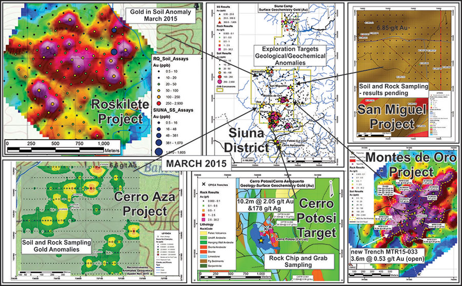
Roskilete Gold Project
Soil sampling at Roskilete (eight km north-west of Montes de Oro) has generated a coherent gold and multi-element anomaly covering an area 1.0km by 1.2km consisting of anomalous gold, copper, and arsenic. This main anomaly includes two trends the first in the central portion trending NE-SW and the second on the southern edge trending N-S. A second anomalous area is located 500 metres to the south and returned weakly anomalous gold with highly elevated values of lead and zinc. The Roskilete area is underlain by andesite volcanics and sediments which have been intruded by diorite. Further follow-up work including trenching is planned.
Cerro Aza Gold Project
Rock sampling at Cerro Aza (five km south-west of Montes de Oro) returned 6.6 g/t Au and 4.5 g/t Ag from a float rock sample of gossanous material within an area where previous soil sampling generated a gold in soil anomaly >750 metres long (open to the north) and 200 metres wide. The area is underlain by volcanic and sedimentary rocks (including limestone) which have been intruded by hornblende porphyry and diorite. The setting is similar to that at Montes de Oro. Further work will consist of additional soil sampling which will extend the grid to the north, as well as further prospecting and geological mapping.
San Miguel Gold Project
At San Miguel (three km north-east of Montes de Oro) soil sampling and geological mapping has been completed over an area of 1.34km2. In total 173 soil samples over 17 lines and 10 rock samples were collected - results are pending. The grid covers the area of a previous rock (float) sample which returned 5.85 g/t Au, 11.1 g/t Ag, 0.29% Pb, and 0.14% Zn. The San Miguel target is underlain by silicified andesite porphyry with disseminated pyrite and centimeter-scale quartz stockwork veinlets exposed on a small resistant ridge consisting of strong argillic and oxide alteration. The showing is located next to a creek, which has been worked for alluvial gold on a small scale.