Eastern Borosi Gold-Silver Riscos De Oro Project
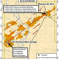
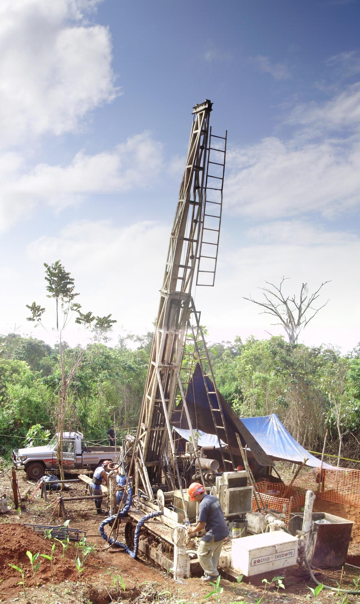
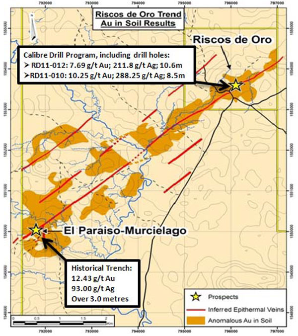
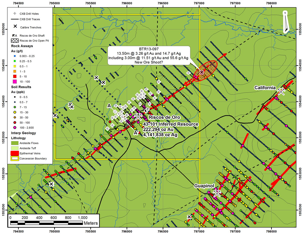
The Riscos de Oro deposit is part of the Eastern Borosi Project and is located 20 kilometres northeast of the historic mining town of Rosita. Riscos de Oro is a southwest trending, low sulphidation epithermal gold-silver quartz vein system that has been traced at surface for over 2 kilometres and has an inferred cumulative strike length of 7 kilometres. Rosario Resources operated a small scale open pit and underground mine at site in the late 1970’s which is estimated to have produced 40,826 ounces of gold and 2,567,808 ounces of silver (Lehman, 1981). The underground development consisted of two levels (150ft and 300ft) accessed by a vertical shaft. Two additional mines were operated in the region by Rosario during the same period exploiting gold and silver from low-sulphidation style epithermal quartz veins (Blag, California).
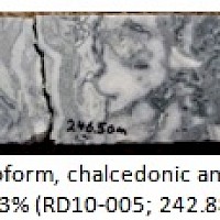
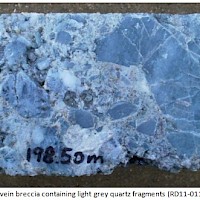
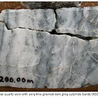
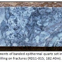
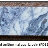
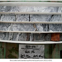
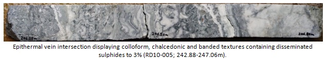
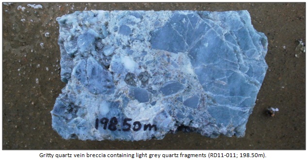
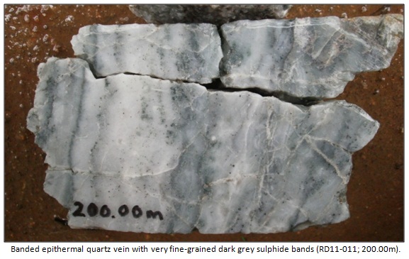
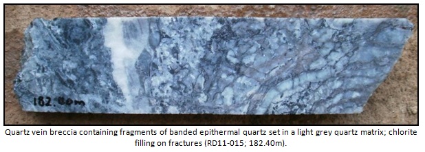
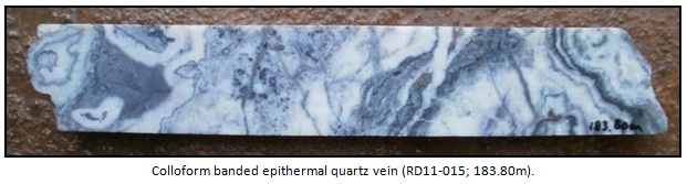
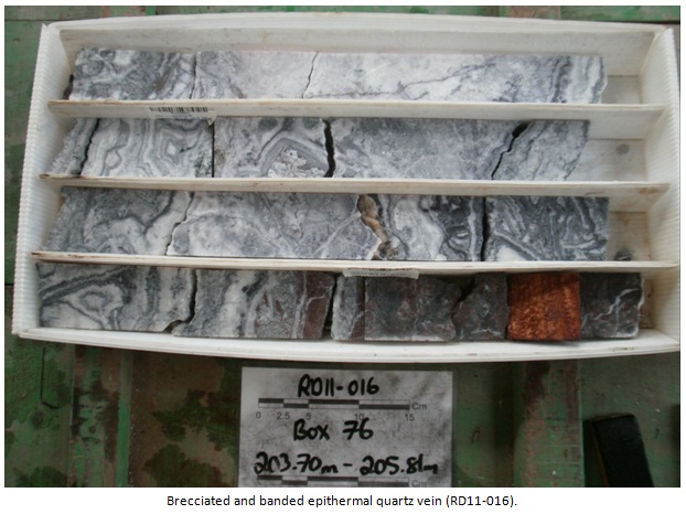
The Riscos de Oro vein system is hosted in an interbedded and variable andesite volcanic sequence that repeats six to ten times at depth. The units have been classified as vent-proximal flows and tuffs with interspersed hypabyssal intrusions (dikes-sills). The sequence transitions from subaerial lithic facies through to coherent flow facies and includes andesitic crystal lithic tuff, hematitic ash tuff, amygdaloidal andesite, porphyritic andesite and aphanitic andesite. The contacts within the sequence are mostly gradational and often do not have definitive contacts. The principal vein has an average orientation of 233/60 (NE-SW) and is believed to have undergone both sinistral strike and normal dip slip during its formation (i.e. oblique slip). Multiple reactivation events are recorded in drill core in the form of reworked quartz vein breccias. Where intact the veins are classic colloform banded low sulphidation style, with a sulphide content ranging from 3% to 10% (see photos below). The observed sulphide assemblage includes pyrite, sphalerite, galena, argentite and minor chalcopyrite. A 2 to 3 metre wide silicified and propylitic alteration halo is often observed in the host rocks immediately adjacent to the veins. Quartz-calcite stockwork veining is also common for several metres surrounding the vein and is more intense in the footwall. In addition to the principal vein at least two other sub-parallel veins have been intersected in drill core both containing significant gold and silver values.
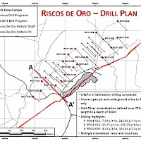
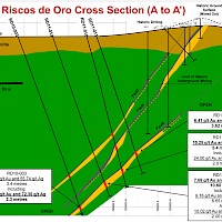
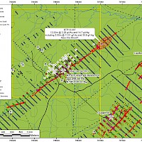
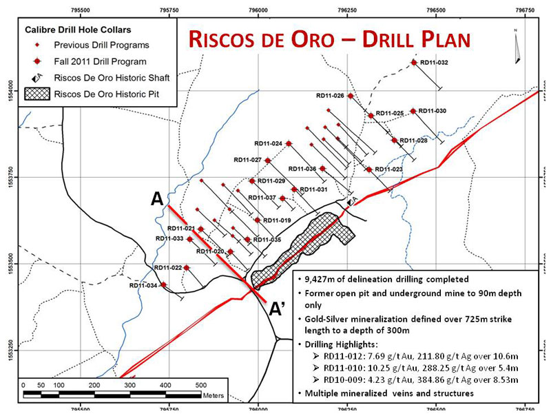
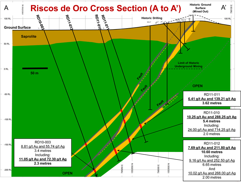
The 2012 Riscos de Oro Mineral Resource estimate is based on 9,494 metres in 37 diamond drill holes completed by Calibre in 2010 and 2011 as well as 22 historic drill holes totaling 3126.8 metres. The drilling was generally spaced at 25 to 50 metre intervals along strike and down dip. Significant drill results were returned over a strike length of 625 metres and to a depth of 300 metres. Vein intercepts ranged from 1.39 to 10.60 metres in width. Additional data related to historical drilling, underground development and past production was used to aid in the geological interpretation. The Riscos de Oro vein system is open for expansion both along strike and at depth. Riscos de Oro is a southwest trending, low sulphidation epithermal gold-silver quartz vein system that has been traced at surface for over 2 kilometres and has an inferred cumulative strike length of 7 kilometres. Rosario Resources operated a small scale open pit and underground mine at site in the late 1970’s which is estimated to have produced 40,826 ounces of gold and 2,567,808 ounces of silver (Lehman, 1981). The underground development consisted of two levels (150ft and 300ft) accessed by a vertical shaft. Two additional mines were operated in the region by Rosario during the same period exploiting gold and silver from low-sulphidation style epithermal quartz veins (Blag, California). The Riscos de Oro vein system is hosted in an interbedded and variable andesite volcanic sequence that repeats six to ten times at depth. The units have been classified as vent-proximal flows and tuffs with interspersed hypabyssal intrusions (dikes-sills). The sequence transitions from subaerial lithic facies through to coherent flow facies and includes andesitic crystal lithic tuff, hematitic ash tuff, amygdaloidal andesite, porphyritic andesite and aphanitic andesite. The contacts within the sequence are mostly gradational and often do not have definitive contacts. The principal vein has an average orientation of 233/60 (NE-SW) and is believed to have undergone both sinistral strike and normal dip slip during its formation (i.e. oblique slip). Multiple reactivation events are recorded in drill core in the form of reworked quartz vein breccias. Where intact the veins are classic colloform banded low sulphidation style, with a sulphide content ranging from 3% to 10% (see photos below). The observed sulphide assemblage includes pyrite, sphalerite, galena, argentite and minor chalcopyrite. A 2 to 3 metre wide silicified and propylitic alteration halo is often observed in the host rocks immediately adjacent to the veins. Quartz-calcite stockwork veining is also common for several metres surrounding the vein and is more intense in the footwall. In addition to the principal vein at least two other sub-parallel veins have been intersected in drill core both containing significant gold and silver values. The 2012 Riscos de Oro Mineral Resource estimate is based on 9,494 metres in 37 diamond drill holes completed by Calibre in 2010 and 2011 as well as 22 historic drill holes totaling 3126.8 metres. The drilling was generally spaced at 25 to 50 metre intervals along strike and down dip. Significant drill results were returned over a strike length of 625 metres and to a depth of 300 metres. Vein intercepts ranged from 1.39 to 10.60 metres in width. Additional data related to historical drilling, underground development and past production was used to aid in the geological interpretation. The Riscos de Oro vein system is open for expansion both along strike and at depth.
Mr. Gregory Smith, P. Geo., president & CEO for Calibre Mining is the qualified Person as defined by NI 43-101 and has prepared and approved the technical data and information on this webpage.

